

 by Gale E. Treiber/photos by the author
When most railfans think of Pittsburgh, they envision the city’s three rivers crossed by many massive railroad bridges and many, many more bridges for automobile traffic. This is quite an accurate picture for the railroad lines that ran, and still run, on almost level trackage laid along the Allegheny, Monongahela, and Ohio River banks. However, Pittsburgh’s suburbs are another story. Small neighborhoods, towns and boroughs grew up in the surrounding hills and in the first half of the 20th Century and were connected to downtown Pittsburgh by numerous Pittsburgh Railway Company (PRC) streetcar lines.
These routes ran up from the rivers and over the hills and then across high bridges when necessary to connect towns separated by deep valleys. I spent the first ten years of my life (1942-1951) in one of those little towns in Pittsburgh’s suburbs — the Borough of Bellevue. Bellevue was about five miles north of Pittsburgh, sitting on a relatively flat area some 300 feet above the Ohio River Valley. The borough had a population of perhaps 7,000 folks back then, and it was served by two streetcar lines from downtown Pittsburgh.
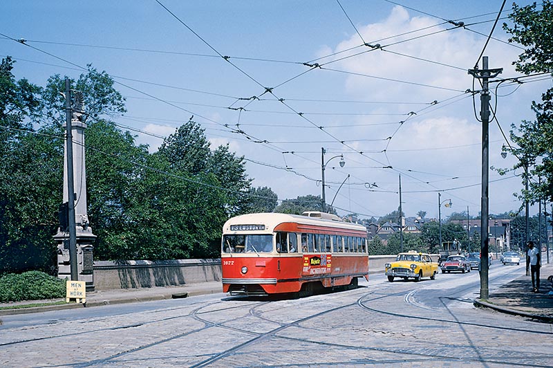
ABOVE: PCC 1677, running inbound on Route 13 EMSWORTH, has just crossed the Jack’s Run Viaduct that connects the Borough of Bellevue with the city of Pittsburgh. The streetcar will continue straight and travel on California Avenue to North Side Pittsburgh, maneuver on various streets to the Sixth Street Bridge over the Allegheny River, go around a couple of blocks in downtown Pittsburgh and then retrace its route back to Emsworth. The tracks in the foreground connect to Route 6 BRIGHTON ROAD, whose return loop is right behind me. In the 1920s, this concrete bridge replaced PRC’s original iron (or steel?) 740-foot long, 152-foot high trestle.
Since my Dad did not get a car until 1949, we, like so many other families, took the streetcars everywhere. My Dad took them to work, of course, but I remember us also using them for trips to the doctor’s office, shopping trips downtown and to Pittsburgh’s Pennsylvania Railroad and Pittsburgh & Lake Erie stations for visits to Beaver Falls to see our relatives. My favorite trips, though, were those into Pittsburgh for kids’ stuff — Pirates baseball games at Forbes Field, visits to the Carnegie Museum, the Buhl Planetarium and the Highland Park Zoo, plus trips to Pittsburgh’s department stores at Christmastime, and those summer-time rides to West View Park, which was North Side Pittsburgh’s amusement park.
Back then, streetcars were really an important part of a Pittsburgher’s life. At this time, in the early 1950s, Pittsburgh had one of the largest streetcar networks in the nation, with 666 PCC cars running over 41 routes — including our two routes through Bellevue. Almost all PRC lines started and ended in downtown Pittsburgh. The line that we used most often was Route 13 EMSWORTH, a 7.5-mile double-tracked route that, after crossing the Allegheny River, worked its way through Pittsburgh’s North Side to California Avenue, then ran up to the Pittsburgh border with Bellevue and after crossing the Jack’s Run Viaduct, ran down the middle of the main avenues through Bellevue, Avalon and Ben Avon to its loop in Emsworth. On its way to Emsworth, Route 13 crossed four substantial bridges that were built by PRC but also used by autos and pedestrians.

ABOVE: The Emsworth route was double-tracked from North Side Pittsburgh all the way to the Emsworth Loop. There were short stretches of business districts in the little towns along the way (Bellevue’s was about four blocks long) but for the most part the line went through pleasant suburban settings. Here inbound PCC #1750 passes through the far end of Bellevue, having just left Avalon. Note the street – cobblestones for the autos, and bricks for PRC trackage. Although many of my old Ektachromes have turned red, I’m glad I kept the slides!
The other Pittsburgh Railways line that ran through Bellevue was the double-tracked Route 15 BELLEVUE. It followed the same trackage out of Pittsburgh to Bellevue, but then turned north from Lincoln Avenue and ran uphill on a series of streets to private right-of-way in the middle of Forest, and then Cornell, Avenues. It then crossed another long high steel PRC bridge that also accommodated autos and pedestrians. After running a short distance through a rather rural area alongside Center Avenue, there was a series of crossovers and a layover point where operators took a short break and changed their roll signs to Route 10 WEST VIEW.
The cars then continued on private right-of-way back to Pittsburgh passing West View Park, the town of West View and Keating Car House where the North Side cars were maintained. There was then a final short stretch of private right-of-way and at the Pittsburgh city limit, the line entered the center of Perrysville Avenue for a short stretch and then turned on to East Street for the run to downtown Pittsburgh. The cars turned in the city and returned to West View and Bellevue running counter-clockwise around their fifteen-mile loop, again stopping at the layover point where the operators changed their roll sign back to Route 15 BELLEVUE…